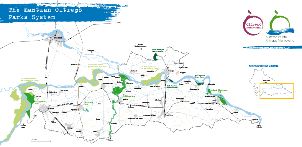
The Mantuan Oltrepò and the Parks System
The Mantuan Oltrepò also conserves amazing natural richness. It is marginal, residual nature that has miraculously survived the agricultural exploitation or has been lovingly reconstructed, whose value increases exponentially due to the presence of the Po, the most extraordinary ecosystem in the Po Plain.
Hence, back in the 1980s the Regional Nature Reserves were set up, the Riserve naturali regionali Paludi di Ostiglia, Isola Boscone and Isola Boschina and, from the 1990s, the local parks of San Lorenzo, San Colombano, Golene di Foce Secchia and Gruccione, leading to the recognition on a European levelin 2006 of the Mantuan section of the River Po, with the establishment of the Special Protection Area “Viadana, Portiolo, San Benedetto Po, Ostiglia”.
Over 9,000 hectares of protected territory, enclosing a cross section of the most significant environments of the Oltrepò, such as sandy areas, oxbow lakes, expanses of water known as “bugni”, willow groves, lowland forests and marshes. An exceptional variety of habitats that host about 300 animal species.

A constellation of wilderness areas which in 2007 joined forces to create the Mantuan Oltrepò Parks System with the aim of combining the protection of the nature with local development through the European Charter for Sustainable Tourism: the reference tool for the tourism policy of the parks of the European Union.
Hence, there was a special focus on the cycle tracks with the creation of the Parks Cycle Route: a path of over 270 km that connects all the wilderness areas of the Parks System, perfectly integrated with the network of the Oltrepò Mantovano cycling itineraries, the cycle routes of the Province of Mantua, the national routes Ciclovia del Sole (Verona-Florence) and VENTO (Venice-Turin), and the international routes EuroVelo 7 (North Cape-Malta), EuroVelo 8 (Cadiz-Cyprus) and Via Claudia Augusta (which connects the Po and Danube rivers).

The natural and semi-natural habitats:
- the woods: willow groves, oak, helm and poplar woods;
- the rivers and flood plains: flowing waters, sandy areas, riparian woodlands, oxbow lakes both active and lying in dead channels, floodwater pools, poplar woods and arable land;
- the marshes: reed thickets, fens and wetland habitats
- the countryside: small lowland forests, hedges, rows of trees, borders of planes, solitary trees, vegetation growing on the banks of ditches and canals (reed and bulrush thickets and fens), wetland habitats in ditches and canals, pulping plants and abandoned quarries, permanent meadows, alfalfa fields, fruit orchards and vineyards, poplar and timber plantations and cultivated land.
The wildlife:
- 235 species of birds;
- 27 species of mammals;
- 26 species of fish;
- 11 species of reptiles;
- 9 species of amphibians.
The history and organization of the Parks System:
The Mantuan Oltrepò Parks System was born in 2007, during the application process for the European Charter for Sustainable Development, when the management bodies of the individual protected wilderness areas signed a specific memorandum of understanding with the aim of establishing ongoing coordination in the spheres of environmental education, utilisation and communication, and of fulfilling the commitments made under the European Charter.
In January 2008 the management rules were approved, which defined the organization of the Parks System based on a decision-making body, the Steering Committee, and an operational body, the Technical Committee, whose members are respectively an administrator and a technical expert put forward by each of the protected wilderness areas concerned. The rules also provided for the establishment of the Parks System Department as an operational organization with Charter Department functions. By the same act, the management bodies approved the strategy and Action Plan of the European Charter, a policy document for the system’s activities.
In December 2008 the Charter Department was set up and in July 2011 an agreement was signed whereby the Consorzio Oltrepò Mantovano (Mantuan Oltrepò Consortium) became a signatory to, and the leading body of, the Memorandum of Understanding which instituted the Parks System.
Download:
Brochure: Sistema Parchi dell’Oltrepò Mantovano (ita)
Brochure: Mantuan Oltrepò Parks System (eng)
Broschüre: System der Parks des Oltrepò von Mantua (deu)
The Parks System in a nutshell
| Protected wilderness area | Municipalities involved | Management Institution | Protection systems | Surface area (ha) |
|---|---|---|---|---|
| Isola Boscone | Borgocarbonara | Parco del Mincio | Riserva naturale regionale Zona di Protezione Speciale Siti di Importanza Comunitaria Zona umida di importanza internazionale | 127,05 |
| Paludi di Ostiglia | Ostiglia | Borgocarbonara | Riserva naturale regionale Zona di Protezione Speciale Siti di Importanza Comunitaria Zona umida di importanza internazionale | 121,68 |
| Isola Boschina | Ostiglia | ERSAF - Regione Lombardia | Riserva naturale regionale Zona di Protezione Speciale Siti di Importanza Comunitaria | 43,74 |
| San Colombano | Suzzara | Comune di Suzzara | Parco Locale di interesse sovracomunale | 556,41 |
| San Lorenzo | Pegognaga | Comune di Pegognaga | Parco Locale di interesse sovracomunale | 38,49 |
| Golene di Foce Secchia | Moglia, Quingentole, Quistello, San Benedetto Po | Consorzio Comuni di Moglia, Quingentole, Quistello, San Benedetto Po e Consorzi di Bonifica Emilia Centrale e Terre dei Gonzaga in Destra Po - Ente capofila: Comune di Quistello | Parco Locale di interesse sovracomunale | 1.177,01 |
| Golenale del Gruccione | Sermide e Felonica | Comune di Sermide e Felonica | Parco Locale di interesse sovracomunale | 388,13 |
| Viadana, Portiolo San Benedetto Po e Ostiglia | Bagnolo S. Vito, Borgo Mantovano, Borgoforte, Casalmaggiore, Dosolo, Mottegiana, Ostiglia, Pomponesco, Quingentole, Revere, San Benedetto Po, Serravalle a Po, Suzzara, Viadana | Parco del Mincio | Zona di Protezione Speciale | 7.055,72 |
| TOTAL AREA | 9.508,23 |


